• Skip to primary navigation
  • Skip to main content
NASA MAAP

NASA MAAP

Multimission Algorithm and Analytics Platform

  • News
  • Explore
    • Science
    • Events
  • Communities
    • Github Discussions
    • ESA MAAP Home
  • Help
    • About MAAP
    • Documentation (ReadTheDocs)
    • Terms of Service
    • Open Policies
    • Bug/Feature Reports (Github)
    • MAAP Status
  • Login
    • Profile
  • Show Search
Hide Search

Publication

Towards global spaceborne lidar biomass: Developing and applying boreal forest biomass models for ICESat-2 laser altimetry data

July 16, 2024

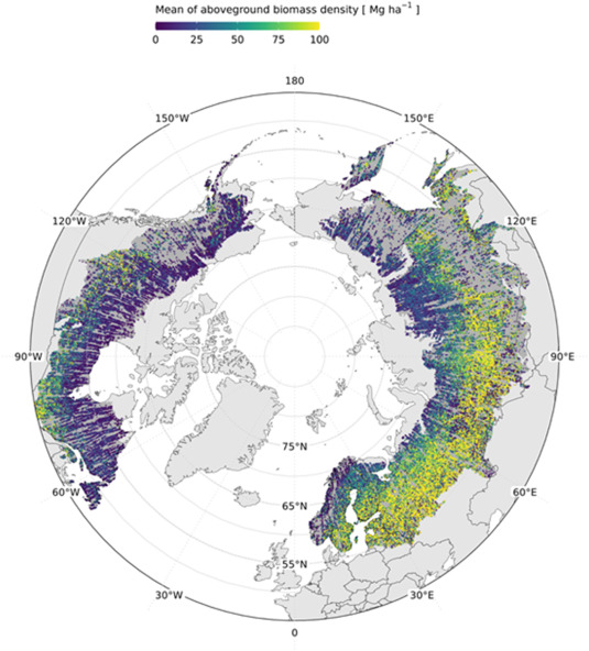
Space-based laser altimetry has revolutionized our capacity to characterize terrestrial ecosystems through the direct observation of vegetation structure and the terrain beneath it. Data from NASA’s ICESat-2 mission provide the first comprehensive look at canopy structure for boreal forests from space-based lidar. The objective of this research was to create ICESat-2 aboveground biomass density (AGBD) models for the global entirety of boreal forests at a 30 m spatial resolution and apply those models to ICESat-2 data from the 2019–2021 period. Although limited in dense canopy, ICESat-2 is the only space-based laser altimeter capable of mapping vegetation in northern latitudes. Along each ICESat-2 orbit track, ground and vegetation height is captured with additional modeling required to characterize biomass. By implementing a similar methodology of estimating AGBD as GEDI, ICESat-2 AGBD estimates can complement GEDI’s estimates for a full global accounting of aboveground carbon. Using a suite of field measurements with contemporaneous airborne lidar data over boreal forests, ICESat-2 photons were simulated over many field sites and the impact of two methods of computing relative height (RH) metrics on AGBD at a 30 m along-track spatial resolution were tested; with and without ground photons. AGBD models were developed specifically for ICESat-2 segments having land cover as either Evergreen Needleleaf or Deciduous Broadleaf Trees, whereas a generalized boreal-wide AGBD model was developed for ICESat-2 segments whose land cover was neither. Applying our AGBD models to a set of over 19 million ICESat-2 observations yielded a 30 m along-track AGBD product for the pan-boreal. The ability demonstrated herein to calculate ICESat-2 biomass estimates at a 30 m spatial resolution provides the scientific underpinning for a full, spatially explicit, global accounting of aboveground biomass.

Reference: https://www.sciencedirect.com/science/article/pii/S2666017224000348

Advancing Data Fusion and Research Collaboration for Global Science Initiatives

December 18, 2023

Sujen Shah will present a poster highlighting several science applications of the MAAP Platform at AGU 2023.

In this presentation, we will delve into the remarkable ways in which various teams have embraced and integrated the MAAP platform, yielding significant achievements. One such success story is the SISTER SBG Pathfinder project, which has seamlessly incorporated the MAAP architecture into their own system by uniquely employing the MAAP for data bulk production in AWS. In doing so, the SISTER team employed the MAAP-style approach throughout the entire product life cycle – from algorithm development to processing workflows, monitoring, and delivery to the Distributed Active Archive Centers (DAACs). 

The Boreal Biomass team under the ABoVE funding has leveraged the MAAP platform to not just do algorithm development, but also scaling up global data-product generation. Furthermore, the work of the Boreal Biomass group has been propelled by the MAAP, culminating in the publication of the first-ever high resolution boreal-wide woody above-ground biomass density product to the ORNL DAAC.

In addition to these accomplishments, we will present how the Biomass group generated per-country summaries using the MAAP’s collaborative and scalable environment. Prior efforts have taken weeks of work but with the MAAP it can be done within a couple of hours.Will also showcase the EIS Fire team’s plans to use the MAAP to generate and deliver near-real-time fire perimeters in the Continental United States and in Canada, Greece and Italy. Unique to the EIS Fire team’s use of the MAAP is continually processing data in a forward “keep-up” basis. 

Join us to explore the transformative impact of the MAAP on global scientific research, data harmonization, and international collaboration, ushering in a new era of innovative and unified Earth observation initiatives.

The poster may be found here: https://agu23.ipostersessions.com/default.aspx?s=09-B8-A4-F6-0C-69-1B-38-37-54-2A-18-45-1F-8E-73&guestview=true

Committee of Earth Observation Satellites (CEOS) Biomass Harmonization

November 23, 2023

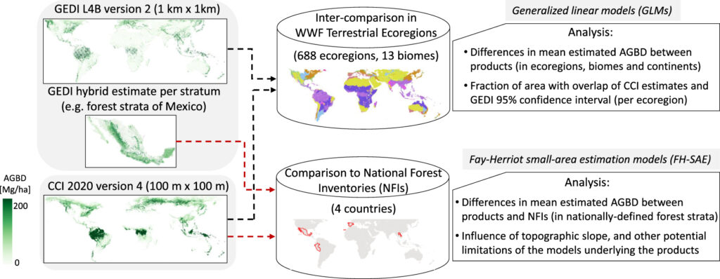
Biomass Harmonization is a coordinated effort of scientists to release forest-carbon estimates obtained with space data in a comparable manner. This helps identify underlying assumptions, definitions and uncertainty-estimation frameworks (Ref 1). By collaborating with scientists and policy-makers in various countries, this effort also aims to align the carbon estimates with policy guidelines, which will ease their uptake for climate reporting purposes. 

An example of this effort is research that leverages data from NASA’s GEDI and ICESat-2 missions, and ESA’s Climate Change Initiative (CCI) to produce IPCC Tier 1 default biomass values for natural forests (Ref 2). The integration of the various space-derived datasets is conducted within an open-science framework (Ref 3) aimed at enhancing the flexibility and adaptability of the estimates by countries. 
The CEOS Biomass Harmonization activity is funded by the NASA Carbon Monitoring Systems (CMS) 2022 and hosted on the NASA MAAP, where open science and a public repository of source code (Ref 4) permits transparency in a collaborative environment between science teams and national policy experts.

References: 

Ref 1 – https://iopscience.iop.org/article/10.1088/1748-9326/ad0b60

Ref 2 – https://authorea.com/users/747800/articles/720021-intergovernmental-panel-on-climate-change-ipcc-tier-1-forest-biomass-estimates-from-earth-observation

Ref 3 – https://daac.ornl.gov/CMS/guides/CMS_Global_Forest_Age.html
Ref 4 – The public Github Repository: https://github.com/CEOSBiomassHarmonization/NASA_CMS/tree/main/NASA_CMS_2023

NASA MAAP

MAAP is a collaboration between ESA and NASA

  • Privacy Policy
  • Accessibility
  • ESA MAAP