• Skip to primary navigation
  • Skip to main content
NASA MAAP

NASA MAAP

Multimission Algorithm and Analytics Platform

  • News
  • Explore
    • Science
    • Events
  • Communities
    • Github Discussions
    • ESA MAAP Home
  • Help
    • About MAAP
    • Documentation (ReadTheDocs)
    • Terms of Service
    • Open Policies
    • Bug/Feature Reports (Github)
    • MAAP Status
  • Login
    • Profile
  • Show Search
Hide Search
Home / News

GEDI Cal/Val Data on the MAAP

September 16, 2019

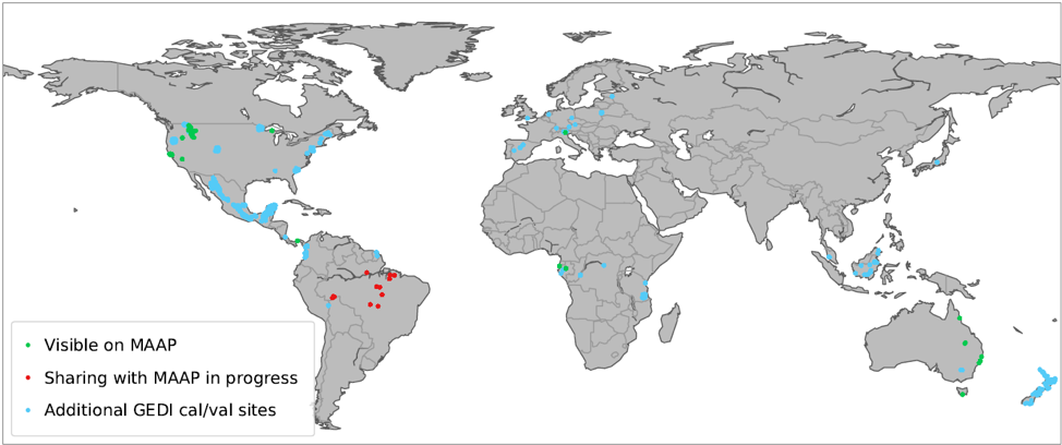
The GEDI team has developed and curated a global field and airborne lidar database to calibrate GEDI’s empirical aboveground biomass algorithms. The publicly-available portion of this database is available on the MAAP, and newly acquired public data will be continually updated. These data are useful for multi-mission biomass calibration and validation activities. So far, the MAAP hosts 25 field datasets and 24 curated coincident lidar datasets (Table 1), which span 4 continents (Figure 1). Through GEDI processing, these datasets have undergone QA/QC activities and have a standardized data and metadata format to promote ease of comparison across locations.

Locations of datasets shared with the MAAP from the GEDI Forest Structure and Biomass Database

Filed Under: News

NASA MAAP

MAAP is a collaboration between ESA and NASA

  • Privacy Policy
  • Accessibility
  • ESA MAAP